
Methodology – Overview
Below is a synthesis of the methodology used to delimit and characterize urban dynamics in Venezuela for the 1985–2024 period for the Urban Module (beta version). This module makes it possible to analyze the country’s urban and peri-urban expansion, as well as attributes associated with vegetation and vulnerability to different physical factors.
Presentation
The MapBiomas Venezuela Urban Module was developed to delimit the country’s urban and peri-urban areas for the 1985–2024 period. Unlike an independent primary spectral classification, this module refines the information from MapBiomas Venezuela Collection 3 land cover and land use data through expert supervision, the integration of complementary sources, and technical-territorial criteria. In addition to delimiting urban and peri-urban space, the module incorporates official place names, political-administrative hierarchies, information on vegetation, and physical vulnerability variables such as fluvial flooding, landslides, and seismicity.
Module Products
This beta version of the Urban Module allows users to visualize the following products:
- Urbanization dynamics and historical expansion of urban and peri-urban areas at annual and five-year intervals.
- Presence and characterization of urban and peri-urban vegetation.
- Hazard exposure analysis, integrating seismicity and hydrogeomorphological variables such as terrain slope and height above the nearest drainage.
Through the public MapBiomas Venezuela platform, users can access these products through maps, statistics, and visualization and analysis tools. The site also provides access to the complete methodology for download here
Method summary
Figure 1 summarizes the main stages followed to construct the Urban Units (UU), defined as the integration of the Urban Area (UA) and the Peri-urban Area (PUA).
The delimitation of the Urban Area (UA) is based on classes 24 (“Urban use”) and 25 (“Other non-vegetated anthropic areas”) from MapBiomas Venezuela Collection 3. From these classes, a continuous urban perimeter was generated by applying a hole-filling tool in polygons (Eliminate Polygon Part) to reduce artificial fragmentation derived from the 30-meter spatial resolution.
To delimit the Peri-urban Area (PUA), the built-up areas layer from the Esri Land Cover Map (2023), derived from 10-meter Sentinel-2 imagery, was used as a reference. Based on this input, area and proximity filters were applied together with criteria validated by experts in urban, environmental, and technical fields. This process made it possible to discard false positives and improve the delimitation of transition spaces between urban and rural areas.
The peri-urban delimitation also incorporated differentiated areas of influence according to the political-administrative hierarchy of populated centers: 1,000 m for state capitals, 750 m for municipal capitals, 500 m for parish capitals, and 250 m for other populated centers. Where legal planning instruments existed, such as Master Plans and Urban Planning Plans, these were used as reference boundaries to define projected growth. Finally, the geometric subtraction between the enclosing area and the UA made it possible to obtain the peri-urban fringe.
As a result, a national layer of 1,124 Urban Units was consolidated, including location information, political-administrative hierarchy, and differentiation between urban area and peri-urban area. For the complete methodology, readers are encouraged to consult the Urban Module ATBD in the corresponding section of the website. ATBD of the Urban Module in the corresponding section of the website.
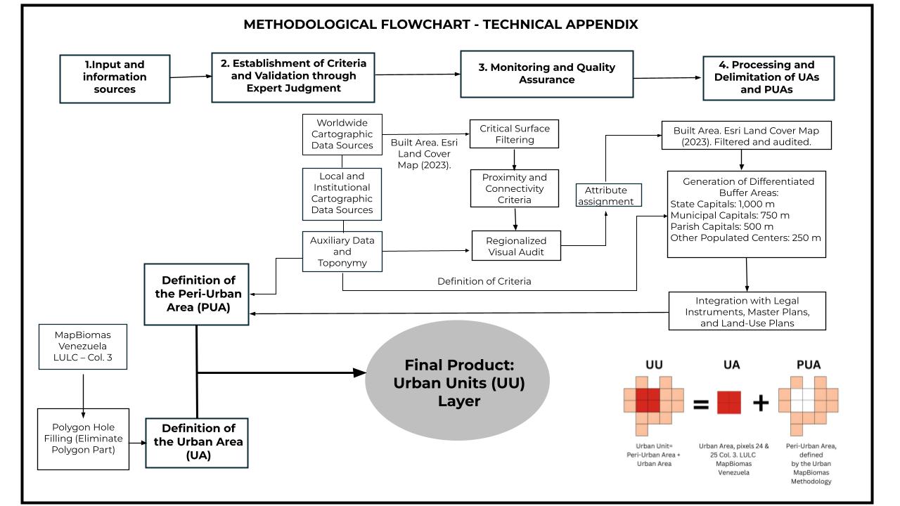
Figure 1. Methodological steps for generating the urban cartography of the module.